
7 days and 7 nights of wet, stormy weather ahead
INDIANAPOLIS (WISH) — We have enjoyed a great end to the weekend with plenty of sunshine and a few high, thin clouds. With all of the sun and a stiff south wind, high temperatures have managed to rise into the mid to upper 40s in most areas Sunday afternoon.

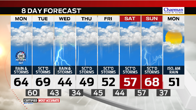
The rising temps and a new southerly breeze are signs that changes are on the way. Rain will return to central Indiana through Sunday’s overnight hours. If you’re headed back to work or school Monday morning, make sure to take rain gear with you, as you’ll need it for the bus stop or as you walk into work. The rain could be heavy at times, so prepare for a few delays on the roads. Temperatures will be on the mild side, even with the rain, with highs set to reach the mid 60s Monday afternoon.

We might catch a bit of a break in the heavy rain in Indianapolis by Monday afternoon, though exact locations of the heavy rain band may vary. Plan for the worst.

Monday is only the first of seven straight days and nights of rain chances in central Indiana.

Flooding will become a big concern as early as mid-week and especially by the end of this work week and next weekend, with most areas set to see at least 2-3 inches of rain in total. Some areas could see much more before things wind down towards the start of next week. Below are two of our major weather models locking in on the widespread wet weather.


Temperatures will remain very mild and even near-record breaking through Tuesday before cooler air moves in by mid-week. Another warm-up will work our way by next weekend with highs in the upper 60s again by next Sunday.

The onslaught of wet and stormy weather looks to finally come to an end by early Monday the 26th, with highs dropping back into the low 50s.
