


Rain returns by Monday with wintry weather through mid-week
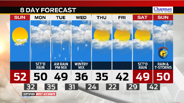
We’re nearly through the second day of a three-day sunny streak here in central Indiana. Highs ended up hitting the upper 40s and low 50s across much of the state with even warmer temps set to slide our direction through the second half of the weekend. However, before we enjoy Sunday’s warmth, we have to get through another cold overnight with clear skies and light winds. Expect temperatures to gradually drop into the upper 20s and low 30s by daybreak.With sunshine and a more southerly wind on Sunday, highs will quickly climb into the 40s by lunchtime, and they’ll eventually top out in the low 50s under mostly sunny skies. A few clouds will slide in late Sunday night, just ahead of our next weathermaker.


The morning commute Monday will be dry for most, though a stray shower is possible. Better rain chances will move in through the afternoon and evening hours, so keep the umbrella handy for the evening commute.


Rain showers will continue into the early hours Tuesday before we catch a break Tuesday afternoon. A cold front will sweep through Tuesday night, bringing a change from rain to light snow showers. The wintry mix will continue through mid-week before we dry out again. Light accumulation is possible.

Temperatures will remain well below average through the second half of the work week with highs only topping out in the mid 30s both Wednesday and Thursday.

We’ll see temperatures rebound a bit by the end of next week and next weekend, but the rising temperatures will arrive with another round of rain and thunderstorms.
