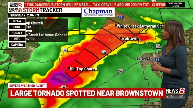
Severe weather strikes central Indiana
INDIANAPOLIS (WISH) — Here’s our running blog on severe weather in central Indiana.
UPDATE: 3:30 p.m.
—
A tornado warning has been issued for Fayette, Franklin and Union counties until 4 p.m.
UPDATE: 3:12 p.m.
Click here to see photos of today’s severe weather.
UPDATE: 3 p.m.
—
A tornado warning has been issued for Franklin and Ripley counties until 3:30 p.m.
UPDATE: 2:55 p.m.
—
The severe thunderstorm warning has been canceled for Bartholomew and Jennings counties.
UPDATE: 2:46 p.m.
—
Decatur County REMC reports about 130 without power south of Greensburg as storms move through the area.
UPDATE: 2:42 p.m.
—
A tornado warning has been issued for Decatur and Jennings counties until 3 p.m.
UPDATE: 2:40 p.m.
—
WISH-TV Facebook fan Steve Jones sent in this picture. It was taken just south of Heltonville around 1:30 p.m.

UPDATE: 2:38 p.m.
—
The tornado warning for Jackson County has expired.
UPDATE: 2:36 p.m.
–
ISP Sgt. Stephen Wheeles posted this video to Twitter. It shows sirens going off west of Brownstown.
UPDATE: 2:34 p.m.
—
The tornado warning for Jennings County has been canceled.
UPDATE: 2:32 p.m.
—
A severe thunderstorm warning has been issued for Bartholomew, Decatur and Jennings counties until 3 p.m.
UPDATE: 2:30 p.m.
—
Indianapolis Public Schools has canceled all after school activities and practices.
IMPORTANT ANNOUNCEMENT – Due to the severe weather forecasted for this evening, all afterschool activities and practices are cancelled. pic.twitter.com/Lr7QgN2IO5— IPS (@IPSSchools) March 14, 2019
UPDATE: 2:29 p.m.
—
ISP Sgt. Stephen Wheeles posted this video to Twitter. It shows hail in western Jackson County shortly after 2 p.m.
Twitter user ToniBloni also shared this video with News 8.
UPDATE: 2:22 p.m.
—
The tornado warning for Lawrence County has been canceled.
UPDATE: 2:11 p.m.
—
Tornado warnings have been extended for Bartholomew, Decatur and Shelby counties until 2:30 p.m.
UPDATE: 2:07 p.m.
—
A tornado warning has been issued for Jennings County until 2:30 p.m.
UPDATE: 1:47 p.m.
—
A tornado warning has been issued for Bartholomew, Decatur and Shelby counties until 2:30 p.m.
UPDATE: 1:49 p.m.
—
According to Storm Track 8’s Marcus Bailey, there is a clear indication of rotation heading toward Columbus.
1:48pm: Still a clear indication of rotation – now heading toward Columbus, IN #INwx https://t.co/J52vLD2TTQ pic.twitter.com/ckhk7zIVuh— Marcus Bailey (@marcusbailey) March 14, 2019
UPDATE: 1:47 p.m.
—
Tornado warnings for Jackson and Lawrence counties have been extended to 2:15 p.m.
UPDATE: 1:34 p.m.
—
A tornado warning has been issued for Bartholomew County until 2 p.m.
Tornado warnings for Brown and Jackson counties have been extended until 2 p.m.
UPDATE 1:17 p.m.
—
A tornado warning has been issued for Brown, Jackson, Lawrence and Monroe counties. These warnings are in effect until 1:45 p.m.
UPDATE: 10:53 a.m.
—
A tornado watch has been issued for much of central Indiana.
The National Weather Service has issued a tornado watch through 5 p.m. Thursday.
Counties in the tornado watch are Bartholomew, Boone, Brown, Clay, Clinton, Daviess, Decatur, Delaware, Greene, Hamilton, Hancock, Hendricks, Henry, Howard, Jackson, Jennings, Johnson, Knox, Lawrence, Madison, Marion, Martin, Monroe, Morgan, Owen, Putnam, Randolph, Rush, Shelby, Sullivan and Tipton.
Storm Track 8 meteorologists expect the so-called “bomb cyclone” storm to reach central Indiana just after lunchtime Thursday.
Earlier Thursday morning, the NOAA Storm Prediction Center upgraded the severe weather risk to “enhanced” for central Indiana.
The storm is called a bomb cyclone to reference the speed at which it develops, according to NOAA.
