Weather blog: Indianapolis drops below freezing for next 10 days at least
Latest weather from Storm Track 8 | Interactive Radar | Download the WISH-TV weather app
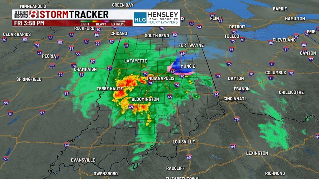
INDIANAPOLIS (WISH) — A winter storm on Friday was rolling through Indiana, bringing snow to northern parts and east central parts of the state, strong winds to east central Indiana, and rain and freezing precipitation to central and southern Indiana.
A flood warning was in effect for the White River at Montezuma, located west of Indianapolis along the borders of Parke and Vermillion counties, through at least noon Saturday.
A winter storm warning was in effect until 7 p.m. Saturday for South Bend and the counties of St. Joseph and Elkhart on the north Indiana border. Additional snow accumulations from 3-6 inches and gusts up to 45 mph were expected.

Winter weather advisories were in effect in parts of northern Indiana, and wind advisories covered most of the state where.
10 p.m.
The National Weather Service at Indianapolis says the temperature dropped below freezing to 31 degrees. Indianapolis isn’t likely to see temperatures above freezing for the next 10 days, maybe longer, as a bitter cold air mass takes over.
9:35 p.m.
Here is the latest travel advisory map from the Indiana Department of Homeland Security. See updates online. Grant and Huntington counties were added Friday night.

9:14 p.m.
8:02 p.m.
The fire department for the Wayne County town of Hagerstown posted photos from crashes during Friday’s storm. Firefighter Matthias Ritter took the photos.


7:39 p.m.
7 p.m.
The National Weather Service office for northern Indiana reported 3 inches of snow on the ground just north of the town of North Webster.
6:56 p.m.
The National Weather Service office for northern Indiana says rain and snow will end Friday evening. Strong gusty winds to 50 mph, falling temperatures, and light snow will arrive from west to east after midnight Friday into daybreak Saturday. Isolated power outages are possible.

6:02 p.m.
5:46 p.m.
The National Weather Service at Indianapolis says temperatures will plummet into the 20s overnight Friday with any lingering moisture on roads freezing into black ice. In addition, light snow may collect on roads Friday evening and overnight, especially areas north of I-70.

5:44 p.m.
5:30 p.m.
Here is the latest travel advisory map from the Indiana Department of Homeland Security. See updates online.

5:14 p.m.
The National Weather Service for northern Indiana says moderate snow will continue north of U.S. 30 through early Friday evening before diminishing as rain south changes back to snow. Additional light snow along with strong gusty winds up to 50 mph and falling temperatures will arrive late Friday night.

4:55 p.m.
Here is the latest travel advisory map from the Indiana Department of Homeland Security. See updates online.

4:13 p.m.
Storm Track 8 reports: Rain is picking back up in central Indiana. Areas northeast of Indianapolis are also still dealing with a mix of snow at times. Expect this heavier precipitation to persist through the evening commute with some snow possibly mixing in at times.
4:09 p.m.
Madison County (Anderson, Elwood) and Monroe County (Bloomington, Ellettsville) as well as Indianapolis and Marion County have announced warming centers and, in some cases, overnight shelter available during the winter storm. See the list at WISHTV.com.
3:25 p.m.
Here is the latest travel advisory map from the Indiana Department of Homeland Security. See updates online.

3:19 p.m.
Here’s from YouTube, is a Friday afternoon briefing on the winter storm from the National Weather Service office for northern Indiana.
2:57 p.m.
2:53 p.m.
Storm Track 8 reports high wind warnings have been expanded northward to include Columbus, Greenfield, New Castle and other locations from 4-8 p.m. Friday for gusts up to 50-60 mph. Additional tree and power line damage possible.

2:10 p.m.
From the National Weather Service at Indianapolis: Rain has changed to snow across parts of eastern Indiana. Snow has quickly covered the roads and led to hazardous travel conditions. If traveling, expect rapidly changing conditions with snow-covered roads east of Indy.

2:05 p.m.
1:45 p.m.
1:15 p.m.
A high wind warning is in effect until 7 p.m. EST/6 p.m. CST Friday for the following Indiana counties: Clark, Crawford, Dubois, Floyd, Harrison, Jefferson, Orange, Perry, Scott, Washington.
The warning includes the cities/towns of Corydon, Jasper, Jeffersonville., New Albany, Paoli, Salem, Scottsburg, Tell City, and Versailles.
Wind gusts will gradually increase in intensity, peaking this afternoon and early evening. Widespread gusts over 50 mph are expected, with sporadic gusts of 58 mph or more this afternoon and early evening. Gusts for much of the overnight hours will range from 40 to 50 mph.
Damaging winds will blow down trees and power lines. Power outages are expected. Travel will be difficult, especially for high profile vehicles.
1:10 p.m.
1 p.m.
As of 1 p.m. EST, 11 Indiana counties are under local travel advisories.

12:50 p.m.
A winter storm warning remains in effect until 7 p.m. EST/6 p.m. CST on Saturday for La Porte and St. Joseph Counties, the Chicago area, and portions of northern Michigan.
The warned area includes Michigan City, La Porte, Granger, South Bend, and Mishawaka.
Heavy snow and blowing snow are expected with total snow accumulations of 4 to 9 inches.
Travel could be very difficult. Widespread blowing snow could significantly reduce visibility. Hazardous conditions could impact the evening commute.
The worst travel conditions from snow and blowing snow will be this evening through Saturday afternoon. Rain will likely mix with snow for most of today which may limit impacts and accumulations before sunset.

12:45 p.m.
The National Weather Service in Indianapolis has updated its wind gust timeline for central Indiana.
Central Indiana could see a few stronger gusts during the day, but the highest winds will arrive this afternoon/evening with possible gusts of 40-50 mph. Power outages are possible.

12 p.m.
11:40 a.m.
Indiana is still on track for a prolonged cold snap beginning Saturday, with possible wind chills as low as -20° F.

11:05 a.m.
10:45 a.m.
10:40 a.m.
10:30 a.m.
Ten counties in northern and northwestern Indiana have issued local travel advisories.
A travel watch means conditions are threatening to the safety of the public. Only essential travel — such as to and from work or in an emergency — is recommended.
A travel advisory is the lowest level of local travel advisory and means that routine travel or activities may be restricted in areas because of a hazardous situation.

10:20 a.m.
Don’t crowd the plow! Give INDOT’s yellow trucks and other city/county plows plenty of space when you’re out on the roads. Avoid passing, especially on two-lane roads.
The safest place to be is a safe distance away — let them plow the way for you!

10:17 a.m.
About 1,980 Duke Energy customers are without power in Seymour. The estimated time of restoration is 2:45 p.m.

10:15 a.m.
A wind advisory is in effect until 12 p.m. EST/11 a.m. CST for Dubois, Crawford, Jefferson, Harrison, Orange, Perry, Scott, and Washington Counties.
Wind gusts this morning will gradually increase in intensity, peaking this afternoon and early evening. Widespread gusts over 50 mph are expected, with sporadic gusts of 58 mph or more this afternoon and early evening. Gusts for much of the overnight hours will range from 40 to 50 mph.
10:11 a.m.
“In Lake County, slideoffs and disabled vehicles due to the weather have police officers busy all over the county. Police officers say the roads in Lake County are now packed with snow.
That, plus blowing and drifting snow are creating hazardous driving conditions, especially on I-65, I-80/94, and Wicker Avenue. Please plan for extra time to reach your destination and allow more time for your vehicle to stop due to slick roadways.” – Sheriff Oscar Martinez Jr. via Facebook
10 a.m.
The National Weather Service in Indianapolis has issued a wind advisory for much of central Indiana due to possible wind gusts over 50 mph.
The advisory went into effect at 10 a.m. and will through 4 a.m. Saturday.
Counties listed under the wind advisory: Bartholomew, Boone, Brown, Carroll, Clay, Clinton, Daviess, Decatur, Delaware, Fountain, Greene, Hamilton, Hancock, Hendricks, Henry, Howard, Jackson, Jennings, Johnson, Knox, Lawrence, Madison, Marion, Martin, Monroe, Montgomery, Morgan, Owen, Parke, Putnam, Randolph, Rush, Shelby, Sullivan, Tippecanoe, Tipton, Vermillion, Vigo, Warren.
9:50 a.m.
Seven Indiana counties are under some level of travel advisory amid a winter storm.

5:12 a.m.
- Download the WISH-TV weather app
- Latest weather from Storm Track 8
- Monroe County fire stations set to open as warming centers during extreme cold
- Insurer: Indiana ranked 15th among states for claims involving frozen pipes
- How to prevent pipes from freezing
- How to protect your home during extreme cold weather
- Animal Care Services set to enforce city law to protect pets during arctic blast
- AES Indiana shares cold weather safety tips in preparation for arctic blast