Indiana is no stranger to severe weather in October
INDIANAPOLIS (WISH) — Here in Indiana, we see the peak of our severe weather activity take place in the spring.
However, fall is known to work up a secondary peak of severe weather in the midwest during the timeframe of October to December.
As we transition towards winter, the polar jet stream gradually moves farther south into more of the mainland U.S. out of Canada. The jet stream is stronger during the fall season, and combining that with higher amounts of moisture can lead to trouble.
Although severe weather in October for us isn’t common, we have seen a few scenarios in which powerful systems roar through in which they bring intense weather. One particular event that comes to mind for Indiana is the late-October 2010 North American storm complex that impacted a great portion of the United States.
The late-October 2010 storm complex was a historical extratropical cyclone that consisted of a wide range of events such as a serial derecho, tornado outbreak, and a blizzard. Extratropical (or mid-latitude) cyclones are defined as large-scale low pressure systems in which they feature large contrasts in temperature over a broad area with either mild or chaotic weather conditions.
This system developed exceptionally quickly to the point in which it was declared a “bomb cyclone” due to the system’s central pressure dropping at least one millibar per hour for 24 hours. High winds of up to 70 MPH would occur over Nebraska on Oct. 24, but this storm system was just getting started.
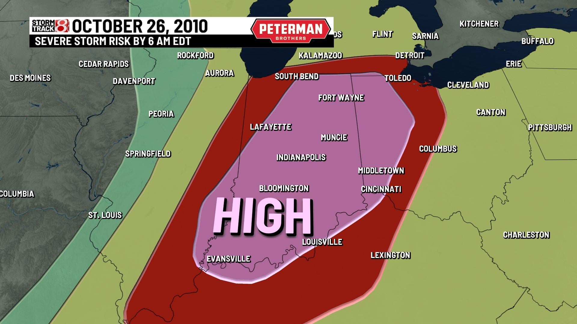
Potent severe weather would take place across Illinois, Indiana, Michigan, and Ohio on Oct. 25th and 26th. Strong winds, hail, rain, and widespread tornadoes all caused havoc. Indiana was gripped with significant winds and a couple of tornadoes during the morning hours of Tuesday, Oct. 26th. The Storm Prediction Center outlined a rare high risk for severe weather across much of Indiana early that same morning, and this included an extremely high wind threat and significant tornado threat.


Damaging wind gusts of up to 60-80 MPH were reported across much of Indiana with cities such as Parker City, Terre Haute, Alexandria, and Greenfield taking the brunt of the higher winds. Indiana also had ten tornadoes in which they were all rated EF0 or EF1 as well.
Not only were the winds considerable across a big portion of the Ohio and Tennessee valleys, but the number of tornadoes that were spawned was also significant. A total of 69 tornadoes were produced from Oct. 23rd to Oct. 27th from the plains to the east coast. The cold side of this system contained a blizzard for portions of North Dakota and Minnesota with St. Louis county, MN receiving nine inches of snow.
This powerful storm complex as a whole became historic because the lowest minimum pressure that was recorded was 955.2 millibars. That made this cyclone the second most intense non-tropical system on record to occur in the continental United States.