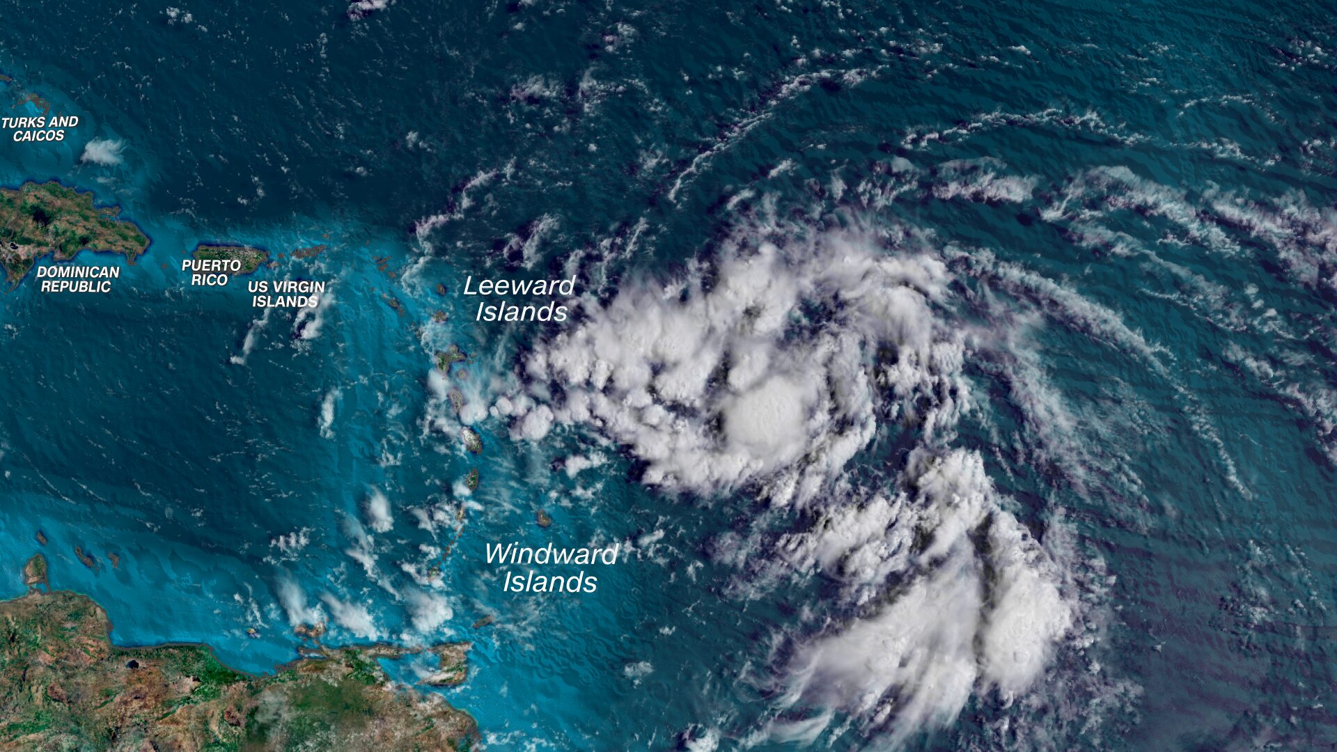
Tropical Storm Ernesto takes aim at Puerto Rico
(CNN) — Tropical Storm Ernesto has formed in the Atlantic and is racing through the Caribbean islands and toward Puerto Rico with heavy rainfall, gusty winds and dangerous seas as a predicted hyperactive hurricane season ramps up.
The center of the storm is moving through the eastern Caribbean’s Leeward Islands Tuesday morning, the National Hurricane Center reported, with maximum winds around 40 mph. The storm was racing west at 20 mph, forecasters at the center said.
The fast-moving system is bringing tropical storm conditions – including potentially damaging winds and heavy rainfall – to the Leeward Islands Tuesday morning. Those conditions will spread across the Virgin Islands and Puerto Rico by Tuesday evening.
Early track forecasts suggest Ernesto will not follow Debby’s continental US-bound path, and will instead curve north and intensify into a hurricane over very warm ocean water, potentially placing Bermuda in harm’s way, instead.
Tropical storm warnings are in effect for Puerto Rico and the Leeward Islands – an island chain in the northeast Caribbean including the US and British Virgin Islands. These warnings mean tropical storm conditions are coming soon. Tropical storms have sustained winds up to 73 mph with stronger gusts and are capable of damaging some structures and taking down trees and power lines. Additional watches and warnings could be be issued in the coming days.
Drenching rainfall looks to be the most significant threat over parts of the eastern and northern Caribbean this week. Rainfall totals of 4 to 6 inches will be widespread, with up to 10 inches possible in parts of Puerto Rico.
“Heavy rainfall may result in locally considerable flash flooding and mudslides,” the National Hurricane Center warned Monday.
Some of the heaviest rain could fall through Wednesday over the Leeward Islands and later Tuesday into Thursday for Puerto Rico.
Tropical storm-force winds will also pound areas within the system’s path from Tuesday onwards. These winds will create dangerous seas and up to 3 feet of storm surge for many islands in the region.
The combination of rain and wind could cause issues for Puerto Rico’s vulnerable electrical infrastructure.
A gradual turn to the north is expected to begin Wednesday, eventually pulling Ernesto away from the Caribbean and into the open Atlantic. Once over open water, Ernesto will strengthen and become a hurricane.
How strong Ernesto gets will depend heavily on very warm ocean water and how potent storm-disrupting upper level winds become over the region. It’s possible Ernesto becomes a major hurricane – Category 3 strength or greater – late this week.
But Ernesto’s track could shift depending on a number of factors, including when it is pulled northward. A later turn would mean the storm would impact areas farther west like Hispaniola or the southern Bahamas.
Ernesto could be a powerful hurricane by the weekend as it approaches Bermuda. It’s too early to know exactly how close Ernesto will come to Bermuda and how much rain and wind it’ll bring.
Ernesto’s will have wide-reaching impacts later this week and this weekend despite an uncertain final track somewhere over the open Atlantic.
The storm will churn up seas hundreds of miles away and could create dangerous rip currents for the US East Coast, the Bahamas and parts of the Caribbean into early next week.


