Weather blog: Tornadoes, storms rolled through central, southern Indiana
Interactive radar | Latest forecast | Download the WISH-TV weather app
INDIANAPOLIS (WISH) — Several rounds of thunderstorms have rolled through Indiana Monday night into Tuesday morning, and more are on the way.
6:02 p.m.
Temperatures will plummet Tuesday night into the upper 30s to low 40s with winds staying breezy. Gusts could be from 25-30 mph at times. On Wednesday, a low-pressure system will practically stall out north of Indianapolis and pinwheel a blanket of showers across Indiana. There will be some snow that mixes in at times. Here’s the latest forecast from Storm Track 8.
5:57 p.m.
Tornado Watches now cancelled across our main WISH-TV 8 viewing area. Still a line of showers from Indy points north that will roll through the next couple of hours.
Expect breezy winds to continue with temps dropping off a lot into WED. WED periodic rain/snow pic.twitter.com/6OMzJX8KIj
— WISH-TV StormTrack8 (@StormTrack8) April 2, 2024
5:51 p.m.
Tornado Warning continues for Dillsboro IN and Cross Plains IN until 6:00 PM EDT
5:42 p.m.
Tornado Warning continues for Dillsboro IN, Cross Plains IN and Rexville IN until 6:00 PM EDT
5:34 p.m.
Severe Thunderstorm Warning including Louisville KY, Jeffersonville IN and Saint Matthews KY until 6:00 PM EDT
5:30 p.m.
Tornado producing storm still in progress near Lancaster, IN in which that will move into and through parts of Jefferson/Ripley/Dearborn counties through 6 PM
Tornado Warning continues for Dillsboro IN, Cross Plains IN and Rexville IN until 6:00 PM EDT
5:27 p.m.
Tornado Warning including Jennings County, IN until 5:45 PM EDT
5:22 p.m.
A special weather statement has been issued for Rushville IN and Glenwood IN until 5:45 PM EDT
5:21 p.m.
Tornado Warning continues for Dupont IN and Canaan IN until 5:30 PM EDT
5:19 p.m.
Tornado Warning continues for Paris Crossing IN and Lovett IN until 5:30 PM EDT
5:15 p.m.
Severe Thunderstorm Warning including Louisville KY, Jeffersonville IN and New Albany IN until 5:45 PM EDT
Tornado Warning including Dillsboro IN, Cross Plains IN and Rexville IN until 6:00 PM EDT
5 p.m.
Tornado reported on the ground near the Jackson/Scott County line
4:54 p.m.
Tornado Warning including Crothersville IN, Vernon IN and Paris Crossing IN until 5:30 PM EDT
4:47 p.m.
Severe Thunderstorm Warning continues for Edinburgh IN, Hope IN and Taylorsville IN until 5:00 PM EDT
4:39 p.m.
Severe Thunderstorm Warning continues for Brown County, IN, Jackson County, IN, Monroe County, IN until 4:45 PM EDT
4:32 p.m.
Severe Thunderstorm Warning including Edinburgh IN, Hope IN and Princes Lakes IN until 5:00 PM EDT
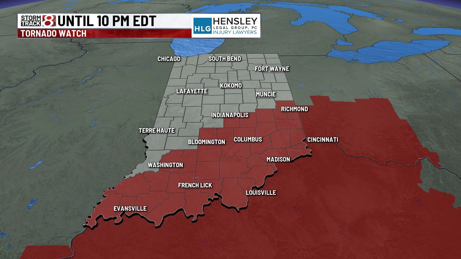
4:29 p.m.
TORNADO WATCH until 10 PM EDT along and east of a line from about Washington to Greenwood to New Castle, IN. Damaging straight-line winds, large hail, and a few tornadoes are possible from storms developing in Indiana as they move east into Ohio and Kentucky. #INwx #nwsind pic.twitter.com/0xOUXU5pXb
— NWS Indianapolis (@NWSIndianapolis) April 2, 2024
4:24 p.m.
Severe Thunderstorm Warning continues for Greenfield IN, New Palestine IN and Morristown IN until 4:30 PM EDT
4:18 p.m.
Severe Thunderstorm Warning including Nashville IN until 4:45 PM EDT
4:17 p.m.
Here we go! As the cold front moves through in the next few hours, funnel clouds and brief weak tornadoes are possible. A Slight Risk (level 2/5) remains from a Marion County, IN to Henry County, OH, with an Enhanced Risk (3/5) for Allen County, OH. Stay weather aware! pic.twitter.com/qmJm1Lfxe1
— NWS Northern Indiana (@NWSIWX) April 2, 2024
4:15 p.m.
Severe Thunderstorm Warning continues for Oolitic IN, Harrodsburg IN and Avoca IN until 4:45 PM EDT
4:01 p.m.
Severe Thunderstorm Warning including Greenwood IN, Franklin IN and Greenfield IN until 4:30 PM EDT
3:58 p.m.
Severe Thunderstorm Warning including Oolitic IN, Harrodsburg IN and Avoca IN until 4:45 PM EDT
Severe Thunderstorm Warning including Lawrence County, IN, Martin County, IN until 4:15 PM EDT
3:53 p.m.
Severe Thunderstorm Warning continues for Martinsville IN, Ellettsville IN and Princes Lakes IN until 4:00 PM EDT
3:46 p.m.
A tornado watch has been issued for parts of Indiana, Kentucky and Ohio until 10 PM EDT
3:37 p.m.
Severe Thunderstorm Warning including Bloomington IN, Martinsville IN and Ellettsville IN until 4:00 PM EDT
3:27 p.m.
A special weather statement has been issued for Bloomington IN, Bedford IN and Washington IN until 4:00 PM EDT
3:02 p.m.
As a cold front approaches our area, there is a conditional chance for severe weather if we can get enough instability. Should storms reach severe levels, all hazards will be possible. Best chances for severe weather will be south and east of Fort Wayne between 4-8 PM EDT. pic.twitter.com/0eY9iDtfgZ
— NWS Northern Indiana (@NWSIWX) April 2, 2024
3:00 p.m.
A special weather statement has been issued for Vincennes IN, Bicknell IN and Odon IN until 3:30 PM EDT
2:38 p.m.
A special weather statement has been issued for Vincennes IN, Bicknell IN and Oaktown IN until 3:00 PM EDT
2:16 p.m.
A special weather statement has been issued for Indianapolis IN, Carmel IN and Fishers IN until 2:45 PM EDT
1:45 p.m.
A special weather statement has been issued for Carmel IN, Noblesville IN and Plainfield IN until 2:15 PM EDT
1:20 p.m.
A special weather statement has been issued for Portland IN, Dunkirk IN and Redkey IN until 1:45 PM EDT
1:18 p.m.
A special weather statement has been issued for Greencastle IN, Brazil IN and Heritage Lake IN until 1:45 PM EDT
12:46 p.m.
The next round of thunderstorms presently south of Indy Metro. Additional strong to severe storms towards this afternoon. #INwx pic.twitter.com/irHv4gInji
— NWS Indianapolis (@NWSIndianapolis) April 2, 2024
12:18 p.m.
A special weather statement has been issued for Greensburg IN, Hope IN and Milroy IN until 12:30 PM EDT
12:04 p.m.
We're keeping an eye these storms in far southern Indiana as they may pose a hail threat. Currently thinking the best locations and timing for severe weather will be south and east of Fort Wayne will be between 4-8 PM EDT, with storms developing as early as 2 PM EDT. https://t.co/kczO3lGdGt
— NWS Northern Indiana (@NWSIWX) April 2, 2024
11:57 a.m.
A special weather statement has been issued for Bloomington IN, Oolitic IN and Harrodsburg IN until 12:30 PM EDT
11:31 a.m.
A special weather statement has been issued for Washington IN, Loogootee IN and Odon IN until 12:00 PM EDT
9:42 a.m.
The NWS in Indianapolis has issued a flood warning for Decatur, Hancock, Johnson, Morgan, Rush, Shelby, Brown, and Monroe counties until 1:15 p.m.
Rivers, creeks, and streams are expected to flood.
8:03 a.m.
Indiana State Police Sgt. Todd Ringle shared on social media that a Super 8 hotel on U.S. 41 near I-64 in Vanderburgh County received structural damage from Tuesday’s storms.
No injuries have been reported.
7:51 a.m.
A tornado warning was issued for Harrison, Crawford, and Perry counties in southern Indiana until 8:15 a.m.
Flying debris will cause damage to mobile homes, roofs, windows, and vehicles.
7:46 a.m.
Drivers on the east side of Indianapolis should use a little extra caution today – underneath the bridge at the intersection of 10th Street and Sherman Drive is flooded.

7:39 a.m.
Indiana State Police Sgt. Todd Ringle with the Evansville Post said multiple trees are down in the Evansville area due to high winds and storms.
Ringle asks drivers in the city to use extra caution.
7:35 a.m.
7:20 a.m.
The NWS of Paducah included Chrisney in a previous warning in southern Indiana.
7:16 a.m.
A tornado warning continues for Lynnville, Winslow, and Otwell until 7:30 a.m. EDT. A warning also continues for Boonville, Santa Claus, and Dale until 6:45 a.m. CDT.
A tornado was indicated on the radar. Pea-sized hail was possible.
7:09 a.m.
7:07 a.m.
A severe thunderstorm warning has been issued for Warrick, Vanderburgh, Spencer, Gibson, and Pike counties until 6:45 a.m. CDT.
The NWS of Paducah says these storms will be destructive for Evansville, Boonville, Chrisney, and Lynnville.
Winds up to 80 mph are likely. Mobile homes, roofs, windows, and vehicles will be damaged. Tree damage and power outages are likely.
7:04 a.m.
A tornado warning has been issued for Boonville, Melody Hill, and Chandler until 6:45 a.m. CDT.
Quarter-sized hail is possible in this area.
6:57 a.m.
A tornado warning has been issued for Fort Branch, Oakland City, and Haubstadt until 6:30 a.m. CDT.
High winds and pea-sized hail are possible.
Other areas that may be impacted include Mackey, Francisco, Somerville, and Spurgeon. Certain parts of I-69 and I-64 will be impacted, as well.
6:54 a.m.
A tornado was confirmed on the ground in Evansville at 5:53 a.m. CDT. A tornado warning is issued until 6:15 a.m. CDT.
Schools in Evansville were said to be on a two-hour delay, a source tells News 8.
6:52 a.m.
The NWS in Paducah has issued a severe thunderstorm warning for southern Vanderburgh and southwestern Posey counties, including multiple counties in northwestern Kentucky and southern Illinois, until 6:15 a.m. CDT.
Winds up to 60 mph are expected. Damage to roofs, siding, and trees is anticipated.
6:42 a.m.
The NWS in Paducah has issued a severe thunderstorm warning for Evansville, Princeton, and Mt. Vernon until 6:30 a.m. CDT.
Winds up to 60 mph and pea-sized hail are possible.
6:37 a.m.
The NWS in Paducah, Kentucky, says a tornado warning has been issued for southwestern Posey county in Indiana until 6 a.m. CDT/7a.m. EDT.
At 5:31 a.m. CDT, a severe thunderstorm capable of producing a tornado was found near Shawneetown in Gallatin County, Illinois. The storm was said to be moving east at 60 mph. Damage to roofs, windows, and vehicles will occur. Damage to trees is likely.
People are asked to avoid windows, and move to the lowest floor in a building. If you are outdoors or in a mobile home or a vehicle, please move to the closest shelter.
5:57 a.m.
A wind advisory will be in place in the upper Wabash Valley from 1 – 8 p.m. Tuesday.
Winds up to 50 mph are expected. The NWS says to use caution while driving and to secure outdoor objects.
5:39 a.m.
NWS of Indianapolis says heavy rains throughout the rest of the day may cause flash flooding across south central Indiana.
The heaviest rain is anticipated early through midmorning, with spotty heavy rain through mid-afternoon. Minor flooding may occur along waterways and low-lying areas.
5:38 a.m.
The NWS of Indianapolis issued a special weather statement for Vincennes, Monroe City, and Wheatland until 6:15 a.m.
Winds up to 55 mph and half-inch-sized hail are possible.
5:20 a.m.
Storm Track 8 meteorologist Ryan Morse said in a post on X that Tuesday is a day we won’t want to see sun after morning rain. A moderate risk for severe storms will remain in place for southeastern Indiana.
Strong storms are likely to fire up again Tuesday afternoon and evening.
5:07 a.m.
The National Weather Service of Indianapolis has issued a severe thunderstorm warning for Greensburg, New Point, and Millhousen until 5:15 a.m.
Winds up to 60 mph and pea-sized hail is possible.
4:53 a.m.
The National Weather Service of Indianapolis has issued a special weather statement for Columbus, Seymour, and North Vernon until 5:15 a.m.
Winds up to 50 mph and half-inched-sized hail are possible.