Icy start, cold Wednesday
INDIANAPOLIS (WISH) – An icy start to Wednesday morning with record-breaking cold! Lows dropped to the upper 20s with a partly cloudy sky. Expect to see a mix of sun and clouds for a good portion of the day. There is a chance of spotty light mix during the afternoon with highs topping out in the mid-40s.
Lows Wednesday night will drop to freezing prompting a freeze warning for the entire state.
![](https://i0.wp.com/www.wishtv.com/wp-content/uploads/2021/04/HIGHS-TODAY-18.jpg?fit=1024%2C576&ssl=1)
![](https://i1.wp.com/www.wishtv.com/wp-content/uploads/2021/04/Today-planner-13.jpg?fit=1024%2C576&ssl=1)
![](https://i0.wp.com/www.wishtv.com/wp-content/uploads/2021/04/future-1-12.jpg?fit=1024%2C576&ssl=1)
![](https://i1.wp.com/www.wishtv.com/wp-content/uploads/2021/04/future-2-8.jpg?fit=1024%2C576&ssl=1)
![](https://i1.wp.com/www.wishtv.com/wp-content/uploads/2021/04/LOWS-TONIGHT-22.jpg?fit=1024%2C576&ssl=1)
![](https://i2.wp.com/www.wishtv.com/wp-content/uploads/2021/04/Freeze-warning-6.jpg?fit=1024%2C576&ssl=1)
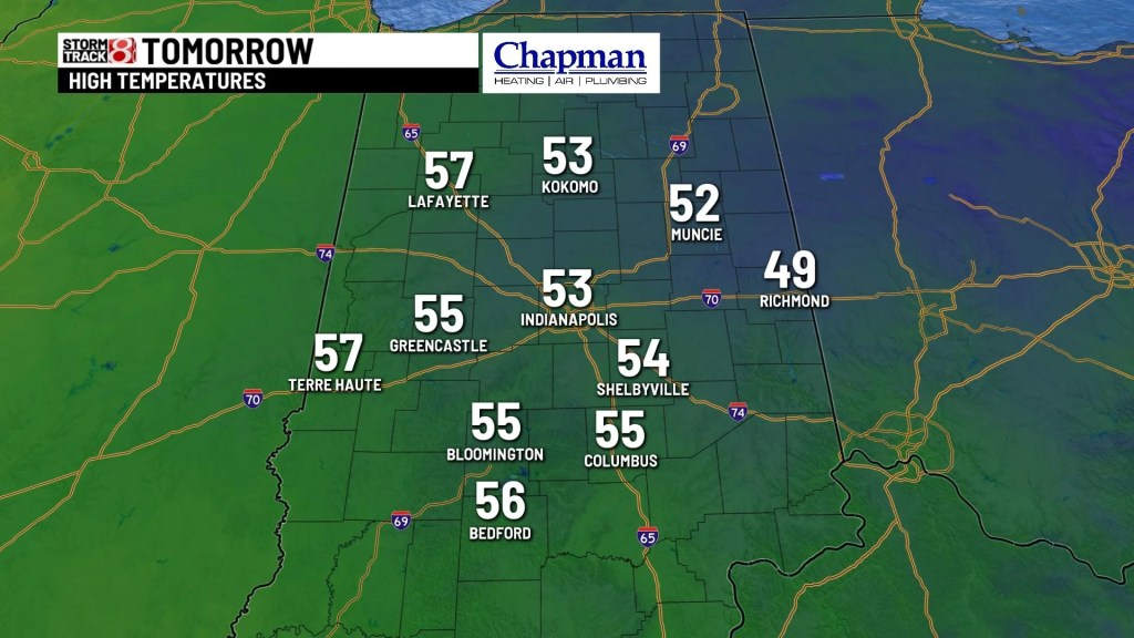
Temperatures will make a quick rebound Thursday with highs in the lower 50s with a partly cloudy sky. We should be nearing 60° by Friday afternoon with sunshine!
![](https://i2.wp.com/www.wishtv.com/wp-content/uploads/2021/04/tomorrow-planner-29.jpg?fit=1024%2C576&ssl=1)
![](https://i2.wp.com/www.wishtv.com/wp-content/uploads/2021/04/HIGHS-TOMORROW-11.jpg?fit=1024%2C576&ssl=1)
This weekend still looks cool but we’re heading in the right direction with highs in the upper 50s and lower 60s Saturday. Scattered showers are possible during the day. A drier start Sunday with a mix of sun and clouds.
![](https://i2.wp.com/www.wishtv.com/wp-content/uploads/2021/04/weekend-forecast.jpg?fit=1024%2C576&ssl=1)
Next week looks beautiful with highs inching closer to the lower 70s Monday! We could see near 80° by mid week next week with plenty of sunshine!
![](https://i1.wp.com/www.wishtv.com/wp-content/uploads/2021/04/8-DAY-4.jpg?fit=1024%2C576&ssl=1)