Top 5 memorable weather events of Randy Ollis’ career
INDIANAPOLIS (WISH) — For 39 years, Randy Ollis has seen it all at WISH-TV. Indiana is a state that can experience the full effects of all four seasons whether it be snowstorms, tornado outbreaks, extreme heat, or flash floods. What are the most memorable weather events Randy has covered from his point of view?
5. Major temperature gradient Feb. 22, 2023
A slow-moving warm front would struggle to lift through parts of central Indiana on the evening of Feb. 22, 2023. This front basically set up right over the top of Randy.
After just a short drive to the north in Carmel, Randy noticed the temperature dropped from 68 degrees to 53 degrees in just the span of a few miles. On StormTracker from the studio, we were able to estimate the 15-degree drop took place only in 3-4 miles.


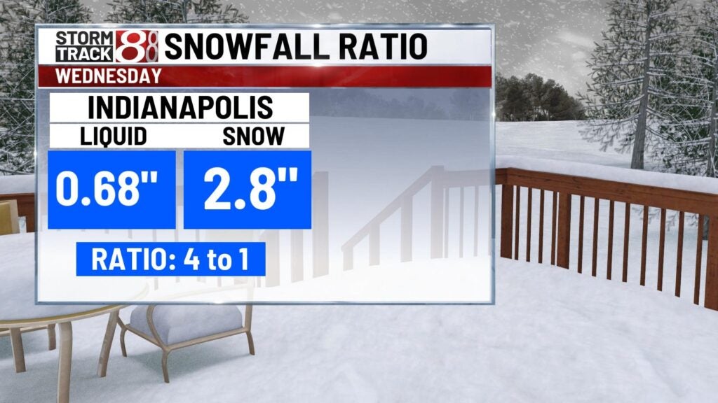
4. Wet snow ratios from the Jan. 25, 2023 snowstorm
Another event from this past year! This was a challenging system to forecast. On this day, there were multiple reports of thundersnow which typically indicates heavy snowfall rates. Warmer-than-anticipated temperatures threw a huge wrinkle into what happened.
“The ratio from this was 4:1 (or) 5:1 it was the heaviest/wet snow of my entire career. It was just amazing, like water in the snow I’ve never seen.”
A rule of thumb snow-to-liquid ratio is usually around 10:1. The warm temperatures in the low levels of the atmosphere contributed to snow melting on its way to the ground. An astonishing 2.8″ of snow had a liquid amount of 0.68″ in it here in Indianapolis.
3. October 1989 early season snow
October is not a month in Indiana we usually look for winter weather. This was not the case in mid-October 1989.
Randy remembers, “Most forecasters said it’s not going to happen, we never had heavy snow this early in the year…but, you know what? The computer (models) were right, and it was the heaviest snowfall that early in the season and that record still stands.”
The earliest measurable snow on record fell on Oct. 18 with the main show on Oct. 19. Not only was this an early snow, but it packed quite a punch. Indianapolis picked up 9.3″ of snow in a shocking event that caught many Hoosiers by surprise.

2. Labor Day Flood Aug. 31 – Sept. 2, 2003
Central Indiana faced major flooding to start the month of September 2003. Tropical Depression Grace would aid in high levels of moisture along a front sliding in the area.
When talking about the difficulty of this forecast Randy said, “I’m always the kind of forecaster that I put out what I think is going to happen and the computer models were showing that we could get 6 to 7 inches of rain.”
Randy nailed this forecast. A shocking 8-9 inches of rain fell that weekend which widespread flooding. Indianapolis set an all-time single-day rain record with 7.2” falling on September 1, 2003.


1. Indiana’s coldest morning ever on Jan. 19, 1994
In prior days, a snowstorm would bring several inches of snow to central Indiana. This would help set the stage for one of the wildest mornings in Indiana history. A big arctic high would move over the fresh snowpack which would be a perfect recipe for radiational cooling with the calm winds and clear skies in place.
“I got into work early that morning and the weather watchers started calling in..what is going on?” Randy recalled.
On the morning of Jan. 19, 1994, Indianapolis would record its all-time record low at -27 degrees. New Whiteland would go on to record the coldest temperature in state history at -36 degrees.


For all the big moments and everything in between, the WISH-TV family congratulates Randy Ollis on 39 wonderful years of helping our viewers and all of us plan each and every day.